▶ CH 04 — APPROACH PLATES

FINALFIX

IFR APPROACH PLATE VIEWER FOR IPAD

Full FAA approach plates with real-time GPS position overlay, voice callouts, and situational awareness for IFR flight. Offline-first. Built for pilots, by a pilot.

⬛ COMING SOON TO THE APP STORE hermes-tv.com →
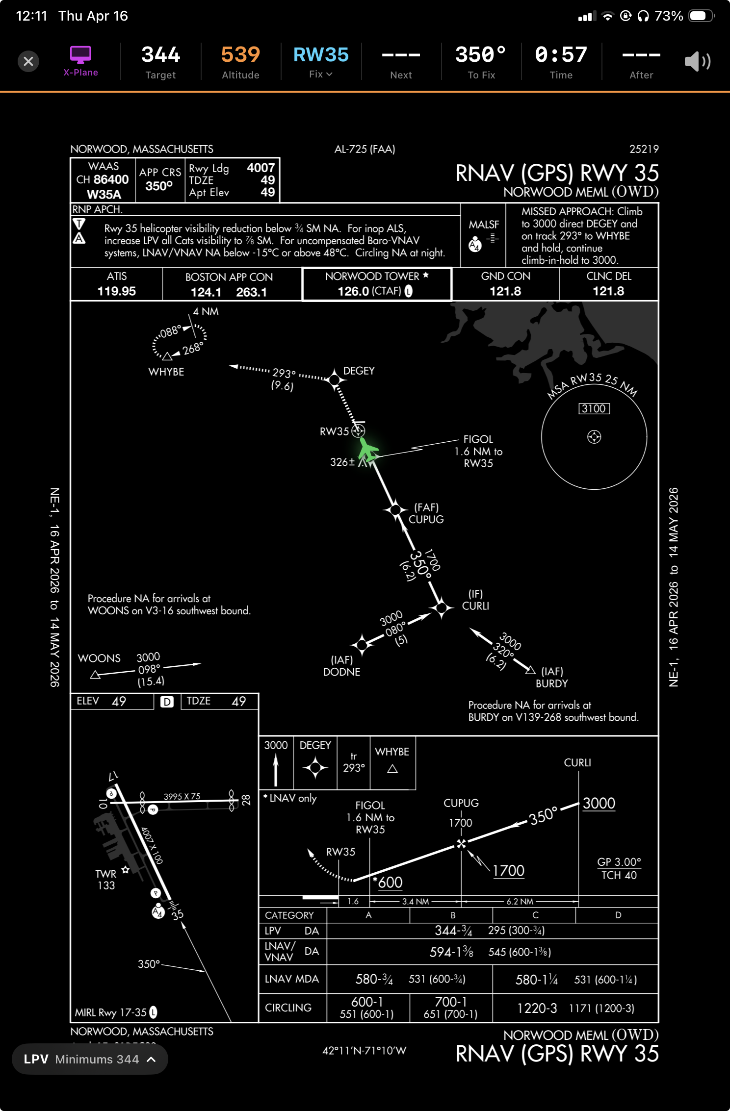
FinalFix — RNAV (GPS) RWY 35 at Norwood MEML with live GPS overlay and ribbon
3,193 US Airports
28 DAY AIRAC Cycle
3 SRC GPS Sources
A–E Aircraft Categories
$0 Price

// CAPABILITIES

Built for the approach briefing
and everything after.

Every feature is there because a pilot needed it in the cockpit — not a product spec.

✈️
GPS Position Overlay
Your aircraft appears on the chart — always in the correct position regardless of zoom or scroll. Updated in real time as you fly the approach.
PDFTKIT · GEOREF
🗣️
Voice Callouts
Audible altitude targets and fix crossings. "Descend to 2,800" as you pass BOSOX. "Minimums" as you reach DA. Keeps eyes outside the cockpit.
AVSPEECHSYNTHESIZER
📡
Live Situational Ribbon
Target altitude, current altitude, next fix, bearing, ETA, and course after fix — all in one persistent strip above the chart. Color-coded for altitude awareness.
REAL-TIME · MAGNETIC HDG
🛬
Minimums Awareness
DA/MDA displayed by aircraft category (A–E). Approaching Minimums and Minimums banners with colored ribbon border. Never miss your altitude.
ILS · LPV · LNAV · LOC
📶
Offline-First
Charts are cached locally. Download by region — Northeast, Southeast, and more. No WiFi needed in the air. Updates automatically each AIRAC cycle.
50 MB ROLLING CACHE
🔀
Transition Auto-Selection
Multiple IAFs? The app picks the nearest one to your position. Tap any fix to jump directly to it, or select a different transition from the dropdown.
CIFP ARINC 424

// INSTRUMENT RIBBON

Everything you need,
always visible.

🖥 X-PLANE
344 Target
539 Altitude
RW35 ▾ Fix
Next
350° To Fix
0:57 Time
After
🔊
Target Required altitude at the next fix. Amber when no minimums set.
Altitude Current pressure altitude. Green = on target. Red = near minimums.
Fix Next waypoint. Tap to change if you have a different transition.
Next Altitude at the fix after next. Orange = descend required. Shows minimums near runway.
To Fix / After Magnetic bearing to current fix, and inbound course for the leg after.

// GPS SOURCES

Three sources. Zero configuration.

All three run simultaneously. The highest-priority source providing valid data wins automatically — no menus, no settings.

PRIORITY 1
GDL 90
Panel-mounted avionics: Avidyne, Garmin, Stratux. Listens on UDP 4000/43211 for GDL 90 broadcast packets. Provides GPS altitude, groundspeed, and track from your panel's GPS receiver.
PANEL AVIONICS
PRIORITY 2
X-PLANE
Simulator on the same WiFi network. Auto-discovered via UDP broadcast — just enable RPOS output in X-Plane and the app finds it. Perfect for flying simulated IFR approaches.
SIMULATOR
PRIORITY 3
DEVICE GPS
iPad's built-in CoreLocation GPS. No external hardware required. Lower update rate than panel avionics but sufficient for pattern and situational awareness in the cockpit.
CORELOCATION

// ALTITUDE AWARENESS

Minimums before you need them.

Configurable approach buffer alerts you when you're close. A hard banner when you're there.

APPROACHING MINIMUMS
344 Target
493 Altitude
RW35 Fix
--- Next
350° To Fix
0:12 Time
--- After
MINIMUMS
344 Target
342 Altitude
RW35 Fix
--- Next
350° To Fix
0:04 Time
--- After

DA/MDA displayed per aircraft category (A through E).
Buffer threshold configurable in settings. Voice callout fires at both stages.

// LAUNCH

Free. For pilots.

Built as a personal tool for flying IFR approaches. No subscription, no in-app purchases. Just a useful cockpit companion.

⬛ COMING SOON TO THE APP STORE

NOT FOR NAVIGATION  ·  FOR SITUATIONAL AWARENESS ONLY